


2050 Land Use Plan
 On August 3, 2020, the Village Board adopted a 2050 Land Use map, replacing the 2035 Land Use map that was set in 2009. The new map was developed over a six-month process that began with a public workshop on January 29. The map was reviewed and revised by the Plan Commission over the course of public meetings held on March 2, May 4 and June 1. A public hearing on the final proposed map was held on August 3.
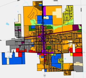
Following are highlights of the 2050 Land Use Map:
- Re-establishes the Union Grove planning area to reflect the Village’s municipal borders based on the incorporation of Yorkville in 2018.
- Creates a “mixed use” category allowing for commercial and/or residential uses within the same property. This category has been applied throughout the main commercial corridor of the Village on Main St. and 15th
- Reflects the most recent concept plans presented for the Canopy Hill subdivision indicating mostly medium-density residential with a portion of high-density residential at the north end.
- Establishes medium-density residential as the land use category for most undeveloped areas of the Village not located within the main commercial corridors.
The land use map serves as a guide for future development and redevelopment activities in the community. It does not impact the current use of a property, which is regulated by the zoning map. The land use map can be amended at the request of a property owner through a land use plan amendment application process.
Project Background
Updating the Land Use Plan is a public process that requires input from Village residents, property owners, business owners and other community members.
To kickoff the project, a public workshop was held on Wednesday, January 29, 2020. The workshop was announced in the December 2019 edition of the Village Voice newsletter, as well as the December and January editions of the Union Grove Monthly E-News. Invitation postcards were mailed in early January to all addresses in the Village and a follow-up announcement was posted on the Union Grove Facebook page.


About 50 people were in attendance for the workshop, which involved a short presentation, group survey and three “stations” covering the topics of current conditions, impacts of development and future opportunities. Participants were asked to provide input on these topics on different display boards. Information covering a variety of topics was provided, including demographics, utilities, school capacity, recent developments, TIF districts, parks/trails, property taxes and more.
Village Planner Craig Huebner prepared a report summarizing the feedback received at the public workshop on January 29. The report also provides initial recommendations for the new 2050 Future Land Use Map for Union Grove. To download the report, click here.
View the workshop materials from the links below:
- Public Workshop Presentation
- Interactive Survey Results
- Your Community Display Boards:
- Planned Land Use Display Boards:
- Future Opportunities Display Boards:
Village Planner Craig Huebner prepared a report summarizing the feedback received at the public workshop on January 29. The report also provides initial recommendations for the new 2050 Future Land Use Map for Union Grove. To download the report, click here.
After the public workshop on January 29, the Plan Commission worked on the land use map at its meetings on March 2, May 4 and June 1. A total of 227 parcels were recommended for a change in their land use category. Many of the proposed changes involve the creation of a “mixed use” category for properties along Main St. and Hwy. 11. The mixed use category allows a blending of commercial and residential uses within the same development.